Hansa GeoPort
An Integration Platform for Geospatial Information and Business Processes
Coastal and inland ports are important service and logistics centres, which serve as gateways to land, water and rail transport systems. Port authorities who are charged with the sustained development of port infrastructure,including ongoing planning, construction and operations, require access to reliable, non-redundant, and up-to-date data.
Hansa GeoPort meets such a requirement. As a web-based GIS system, Hansa GeoPort can incorporate both data and applications. Functionality can be implemented according to user needs ranging from pure information services through data capture to specialist applications. Current specialist systems do not need to be discarded nor do new business processes need to be implemented. Rather all the data from various specialist areas is sub-sumed under one unified and intuitive interface to be accessed for needs-based, cross-speciality visualisation, analysis and data maintenance.
In addition data can be supplemented by drawing on the data sets of public bodies such as digital cadastral maps, bathymetric data, water-level / tidal information, electronic navigation charts from waterways authorities since theapplication conforms to ISO / open geospatial consortium (OGC) interface standards
Land in Sight! Land Management out of the Bird's Eye View
Port areas consist of a wide network of large-scale properties / facilities which must be administered and commercially managed. Commercial management requires information - where exactly are the properties situated, how are they currently being utilised, are they commercially viable to be let / sold, have they got good access to road and rail transport systems? The bird’s eye view can return quick answers to these questions.
Hansa GeoPort clarifies the details about all your property assets. On the basis of legal cadastral data, managed properties with alphanumeric information are given a spatial reference which can be displayed in a map. All information concerning the property - its current state and use (by whom, for what) can then be seen at a glance. Additional alphanumeric property information such as leaser, lease value, and lease duration are a mouse click away. Searches for properties with shared data is easy; a search returns a list in tabular form, the details of which can then be displayed on the relevant map. User access is controlled by an authorisation model which runs in the background, based on pre-specified permissions.

The dominant business system used for property administration can be retained. In such a case Hansa GeoPort allows the business system to link directly to the geographic information about properties establishing a seamless connection between the map and property administration system software, in both directions.
Sustainable Port Development and Environmental Protection
Ever expanding cargo volumes have increased the need for the modification and expansion of port facilities. Environmental laws often require that property modification / expansion be accompanied by the creation of measures designed to protect the natural environment. This may include the development of new areas reserved as protected landscape. Such measures require planning, development and monitoring.
Hansa GeoPort can support port modification / expansion by identifying areas suitable for development as protected landscape. Ongoing works, environmental expert reports, and relevant areas can be clearly displayed and reports generated. Port authority owned or publicly available aerial imagery can provide additional details.
It is not necessary to have a specialist application in order to manage environmental data. Such data can also be supplemented and documented directly, through Hansa GeoPort over a web-browser, allowing authorised users to work with the data directly and to carry out a wide range of geoinformation and documentary functions. The complications of installation on a local work station are not necessary.
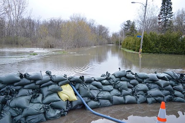
A further factor to be considered is changes in environmental conditions and regulations eg take the case of flood control. Ports and their surrounding areas need to be well protected from flooding. Locks (their gates and sluices), dykes and outlets all need regular inspection. The heights of the dyke walls have to be checked and if necessary adjusted / aligned to each other. Hansa GeoPort can support such a process. Up-to-date 3D laser survey height data can be integrated into a map with a single click, and the relevant cross-section generated.

Maintenance of Land-Based and Water Infrastructure
The maintenance and administration of property infrastructure is a complex and challenging undertaking. Waterways, rail tracks, roads and technical facilities require a multifaceted approach drawing on many specialities. A wide spectrum of technical data has to be kept up-to-date, and maintenance schedules have to be planned, carried out and documented.
Hansa GeoPort can serve as an integration and information platform for all these facets of port information management. For example water level gauge plans and minimal depth data can be supplied in nearly realtime. Key technical data about structures can be retrieved and displayed at a mouse click. Maintenance schedules can be displayed, while faults notifications can be dealt with, centrally. The integration of utility plans (electricity, water, sewerage) with an already completed ground investigation facilitates a quick pre-assessment of construction projects and can help in the optimising of costly subsoil investigations / analysis.
In addition search and queries can be carried out targeting a wide range of variables and information. Search results are displayed in a list, and can be displayed on a map. The user can retrieve any available information, collocate it and generate it in PDF format.
Sensor Integration and Live Data

A further advantage of Hansa GeoPort is its ability to integrate the live data from a wide variety of sensors, and to display the results, according to user requirements. For example AIS ship position with all other transmitted data can be superimposed on a map which comprises other layers. A search function for ship name, IMO / ENI number, type and other similar parameters is available.
Similar facilities are available for integrating of live-stream imagery from web and company cameras. The display of live data from water level gauges / meters, whether from their own sensors or those of the water authority is also straight forward and easily implemented.
Live data from sensors for wind speed and direction, current flow and direction can also be integrated with parameters such as geographic position, map display, and search results. All with one mouse click.

Hansa Luftbild has extensive experience in coastal and inland port projects. Over the last twenty years the company has successfully completed many such projects, for a range of clients, and is also currently involved in a number of ongoing developments.
Hansa GeoPort brings all your data under one roof, freeing you up to concentrate on core business. The various isolated data islands spread across your organization’s departments can be integrated under one standardized search and analysis interface. On the basis of reliable and redundant-free data, you are enabled to make informed decisions for your port planning, construction, and maintenance.
This will reduce costs, and increase information transparency, ultimately ensuring sustainable development and the continuing operation of your port.
Advantages of Using Hansa GeoPort
- This open and transparent system allows you to select at interface level which data sets, processes, and functions should be made available for data maintenance, visualisation / display and the analysis of results.
- Combine your currently available, valuable geoinformation for a reliable base of information on which to base your planning and decision.
- The client stands at centre stage in the development of our system. Invest in our tailor-made solutions, which meet your particular business requirements, rather than in the standard products of large software companies.
- The powerful edit functions (new, change, delete) available for geographic and alphanumeric information mean that you can keep your data current at all times.
- A flexible authorisation and user set-up, limits system users to working on and viewing only that data relevant to their tasks.
- We have made use of modern, continually developing technology which allows seamless integration with your IT system, system stability, reliability and low administrative costs.


Contacts
Download
2-seitiger Flyer:
Hansa GeoPort
News
 28.09.2020
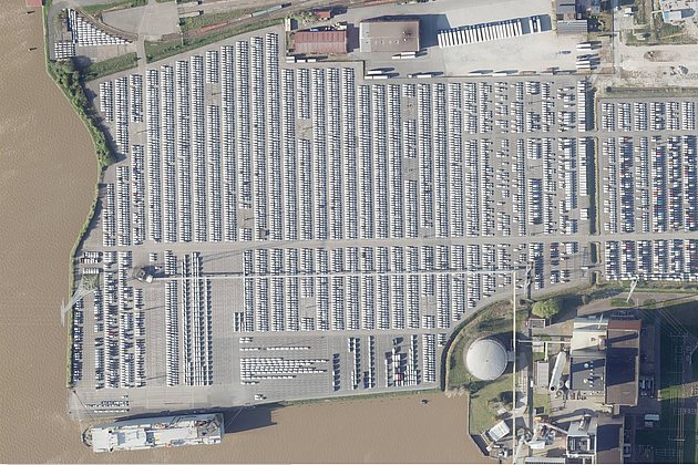
Aerial photo of the month: Cars at Emden harbour
More than a thousand white rectangles can be seen on the open ground of Emden harbour. Whoever takes a closer look can recognise precisely parked cars wrapped in white protective covers waiting to be freighted elsewhere. At the bottom left of the photo, lying in the brownish water of the inner harbour, a Japanese shipping company has docked its vessel.
 25.02.2020
Update - “HafenGIS” (PortGIS) at bremenports (Port of Bremen)
For many years bremenports has been making use of Hansa Luftbild’s web based GIS “Expermaps” for the management of their spatial data. Recently its functionality has been extensively expanded.
 05.04.2019
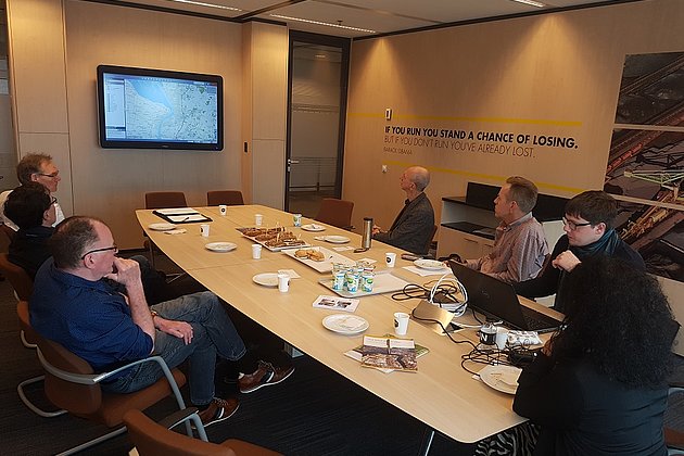
Hansa Luftbild and bremenports visiting the Port of Rotterdam
At the invitation of the Port of Rotterdam, representatives of Hansa Luftbild and the port operator bremenports GmbH visited the port administration of the Dutch Port of Rotterdam in Rotterdam at the end of March. The aim of the visit was to exchange information on the design and the application of corporate geoinformation portals for port administrations.