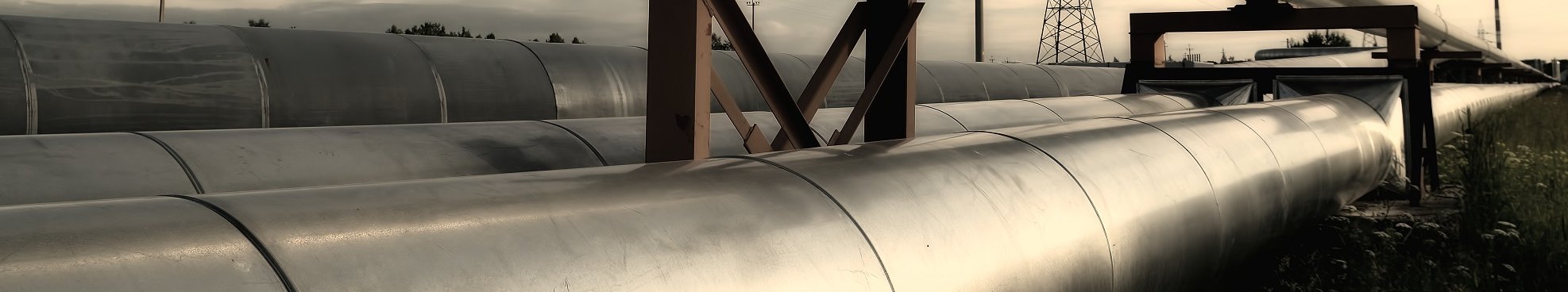
Airborne Corridor Mapping
Hansa Luftbild - A Reliable Partner for the Energy Sector
Airborne corridor mapping is ideal for the planning, documentation, survey and monitoring of overhead power line, pipeline, street and road network corridors. In only one survey flight HLB can capture all required data by using a combination of laser scanning, digital / thermal cameras and differential GPS. Such an approach is cost effective, accurate and fast.
With the increasing significance of renewable energy and continued development of public power supply energy sector companies are faced with varied demands: base data for identifying suitable sites, support for pipeline planning, management of the electric power network and the development of geodata infrastructures to support efficient energy management.
If your organisation primarily requires a terrain or surface model then aerial photography, with certain provisos, is the most suitable approach. You can read more here.
Airborne laser scanning for planning, realignment of corridors, and monitoring
Airborne laser scanning (ALS) is a key technology for resource documentation and planning for local and long-distance networks for power, oil and district heating supply.
Whether for new planning, corridor realignment or corridor management: the data is precise and accurate - fast, cost effective and does not require time consuming on-site inspections. ALS is flexible having many possible applications both onshore and offshore.


Quality and Precision
Our high-performance remote sensing systems and our extensive experience in data capture and processing means that we can deliver data with exact positioning, high quality and precise detailing; also for areas of dense vegetation or impassable terrain.
The base data is supplemented with high-resolution vertical and oblique imagery acquired simultaneously and processed photogrammetrically to produce orthophotos.
Efficient and Reliable Monitoring
We deliver all corridor relevant details, as for example in the capture of overhead power line elements for corridor realignment. This would include the capture of mast and portal, as well as accurate capture of cable / line course, and traverse or line suspension points. Survey of changes in topography, caused for example by ground subsidence, will assist you in facilitating the long-term maintenance of the functionality of your net.

Our corridor management services also include the analysis of obstacles / dangerous objects and the calculation of the distance to surrounding vegetation or buildings.
Contact

Download
6-page Flyer:
Airborne Corridor-Mapping
4-page Flyer:
Pipeline Life Cycle Management
Video:
Airborne Laserscanning - Corridor Mapping for pipelines (route planning for gas pipeline)
Video:
Airborne Laserscanning - Corridor Mapping for pipelines (monitoring of gas pipeline)
News
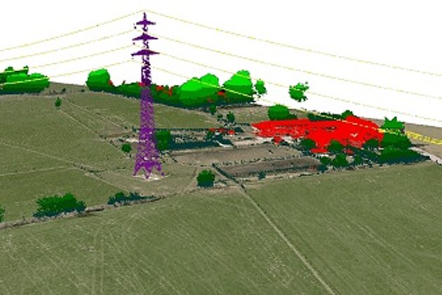
 mit Hochspannungsleitung (violett)") 22.09.2020
22.09.2020Alignment Planning: LiDAR for a long underground power line
The Dortmund electrical power transmission operator Amprion GmbH will soon have a further long power line: the direct current connection “A-Nord” from Lower Saxony to the Rhineland. Hansa Luftbild AG is providing support to Amprion GmbH, the second largest high tension grid operator in Germany, in…
 17.02.2020
Laser scanning during low water levels and for flood protection
The River Schwarze Elster in Brandenburg has recently been subject to close examination. In summer 2019 there were problems with extremely low water levels which at the same time offered the opportunity to survey the river bed accurately. Now the Brandenburg authorities are concerned that the dykes…
Ecological Corridor Management and Analysis of Hazards
Apart from offering the classical landscape survey services needed by energy providers for planning and its approval application procedures, we also offer services which support an ecologically oriented approach to the maintenance and upkeep of corridors and properties. So your facilities can comply with the increasing ecological demands from both the authorities and the public.
Landscape Planning Services
We can support you with a wide range of services for planning and its approval application procedures. These services include:
- Environmental impact studies and landscape conservation plans
- Species protection law reports and detailed mapping
- Implementation planning and ecological supervision of construction.

Planning and application for its approval is no longer the only component of the energy supply company’s continuing development of its services. Further considerations now include the environmental impact the extension and operation of the current network could have; environmental protection needs and the appearance of the landscape must be appraised in determining suitable locations for new wind energy installations; and the open discussion of these themes is now required by both the authorities and the public.

Ecological Corridor Management
Our working model of “ecological corridor management” offers a range of services which deliver double advantages to the client. The upkeep and maintenance of corridors and property can be ecologically implemented while at the same time the safety of network operations can be ensured.
Our precise compilation of remote sensing data and implementation of GIS will give you top quality products and services:
- feasibility studies, location determination, corridor and location analysis
- aerial imagery supported, complete coverage biotope type mapping with the capture of protected biotope and reporting on potential hazards and developments along alignments
- methodology for ecologically sustainable management of your property
- registration of tree information as a basis for determining potential hazards and ensuring the continuing safety of your operations
- monitoring of compensatory and replacement areas, planning and concepts for your compensation areas as well as ongoing evaluation of their success
- visualisation of all data (digital cartography, GIS, WebGIS, server based GeoPortal)
Geodata Management, GIS and Individual Software Development
The new directions in the energy sector have led to new demands. Many types of data sets must be made available to a wide range of users for planning, information, and decision making. Our geospatial software specialists can help you with this challenge assisting you to integrate geoinformation into your business processes.
Establishing, Setting up, and Managing Geodata (Big Data)
The amount of data available and its sources is expanding continually. Apart from the standard geodata of CAD and GIS less structured sources such as texts, photos or videos are now incorporated into data sets. The challenge for organizations is to analyse, process and manage this data making it accessible to the ever-increasing numbers of internal and external users.

Take advantage of our expertise in planning, implementing and running medium and extremely large (over 10 million geodata sets) geo databases. As an Oracle Gold Partner we implement with the database system Oracle Spatial or the open source platform PostGIS according to the database size and client requirements.

Individual Software Development
In the dynamic energy sector a software provider must be able to provide tailored solutions within a short time frame. Our software developers and database specialists can provide flexible solutions within short time frames: we can develop tailored solutions based on reputable software products such as Intergraph GeoMedia or can utilize licence-free opens source components such as GeoServer, PostGIS and GeoEXT.
Your system will be tailored to exactly meet your requirements and be able to be seamlessly integrated into your IT environment and business processes.
WebGIS as an Information Portal
Browser based WebGIS portals are the obvious choice to making centrally administered spatial information available to a wide range of users.
Thanks to the intuitive feel of WebGIS even the less experienced user of geodata can access the information, in a simple and straightforward manner, and apply varying questions to their daily business processes. In this is its greatest utility: geodata portals manage widely varying, complex data sources combining and delivering them in an understandable environment which enables a clear analysis and reading of the information.
Our experience and knowledge of the development of WebGIS portals has been acquired working with a wide variety of clients both nationally and internationally. Thanks to our wealth of experience in geodata management and our ability to develop individual, tailored solutions we can develop for you scalable and low maintenance solutions.

Technology for Geodata Capture
Hansa Luftbild has access to aircraft, helicopters, drones, large format digital cameras, laser scanners, and a wide range of other remote sensing systems. The range of remote capture technologies and equipment has increased dramatically in recent years. The results and analysis of captured data is faster and less expensive than in previous years.
High-tech Quality
We are in a position to capture data, quickly and inexpensively, by aircraft, helicopter, or drone; in offshore or onshore locations, and in areas of impassable terrain without regard to the density of the vegetation.
Energy providers and network operators can benefit from our extensive catalogue of services:
- Production of aerial photos and orthophotos
- Photogrammetric surveys
- Airborne laser scanning of alignments and large areas
- Detailed capture of suspended cables on power masts or industrial facilities with high resolution videos
- Analysis of solar potential with highly accurate 3D compilation of roof geometry
- Calculation of vegetation indices for researching the affects of underground cables on plant growth
- Investigation of vegetation and geology using hyperspectral cameras


- Bathymetric measurement using laser scanning and echo-sounding equipment
- Night data capture for the investigation of light emissions
- Oblique aerial photography with multi-perspective camera systems
We have extensive experience in many lands and can advise on, or manage your overseas projects. Our aircraft and remote sensing equipment - also independent of each other - are available for hire.
Related Services

Aerial Surveys & Orthophotos
The basis for every GIS, for digital surface models, for every cadastre, for every query.
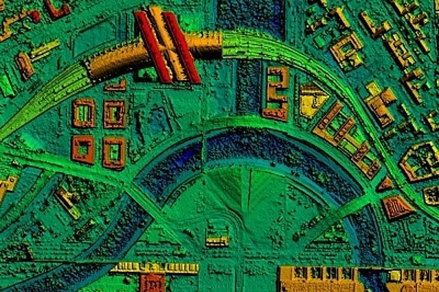
Light Detection and Ranging (LiDAR)
Dense point clouds are the basis for classified terrain and surface models of corridors.

International Consulting
Organisation & company with international geo-focus looking for partner: Hansa Luftbild speciality since 1923
Surface & Terrain Models
3d models of topography, objects and surfaces - made for visualisation and simulation