Urban Flash Floods
Precautionary concept for municipalities
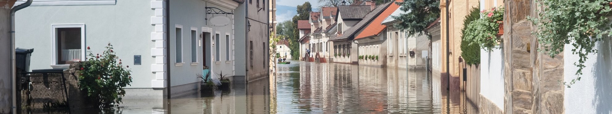
Urban flash floods after heavy rainfall can affect any municipality: sealed settlement areas are particularly at risk. But unlike floods there is no pre-warning during heavy rainfall: the mud flood comes from above, with a high flow velocity and high destructive force. If the water can neither seep away nor run off in a controlled manner, it makes its own way. News of washed-out streets and flooded cellars is becoming more and more frequent - even from previously spared communities. Often already during the clean-up work the population and politics ask the question about the "why".

Reasons for the fatal consequences of flash floods are the surface sealing of areas and undersized infrastructure such as retention basins, sewers and pumping stations. While some municipalities and cities take precautions against urban flash floods, others still underestimate the risk.
Inventory
By taking stock of the surface sealing on the basis of current aerial photographs, the sealing situation of each property is documented and problem areas are obvious.
Simulation
On the basis of sealing and land use data we simulate different heavy rainfall events. In addition to the flow paths and directions of the flash floods, we plot floodplains, taking into account the capacity of the sewer system.
Maesures / action concept
Preventive road, green space and urban land use planning, adaptation of the canal network, unsealing measures, public relations work, municipal and private property protection and similar can now be targeted.
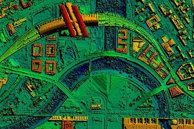
Terrain Model
From the 3D aerial photographs or laser scan data, we create a terrain or surface model of the settlement areas. Sinks and potential flow paths of the surface water can now be identified. And hydraulic calculations become possible.
Hazard and risk analysis
All data is analysed GIS-based. Hazard maps depict flow paths, sinks, water bodies, obstacles and bottlenecks, areas with unsealing potential, critical infrastructure such as hospitals, electrical supply facilities, landfills, protection and retention facilities, etc. This results in areas where action is required and the potential damage in the event of a case can be estimated.
The measures will be implemented under consideration of technical standards, such as the paper of the State Office for Nature, the Environment and Consumer Protection North Rhine-Westphalia on the "Recording of unsealing potentials in NRW". Fire brigades and disaster control also benefit from the hazard maps. They can optimize their schedules at an early stage and thus reduce response times.

Advantages of our Services
- Solutions and action concepts tailored to your needs
- Investing in the future and protecting your community with foresight
- Securing your municipality through precautionary measures against claims for damages
- High quality through decades of experience and competence
- Professionalism from a single source

Contact

Ralf Sembritzki
Sales
+49 170 9690289 | E-Mail
News
 17.02.2020
Laser scanning during low water levels and for flood protection
The River Schwarze Elster in Brandenburg has recently been subject to close examination. In summer 2019 there were problems with extremely low water levels which at the same time offered the opportunity to survey the river bed accurately. Now the Brandenburg authorities are concerned that the dykes may not offer sufficient protection during times of high river levels and flooding. So the river has been documented twice using laser scanning.
Again at Intergeo!
At Intergeo 2019 in Stuttgart from 17 to 19 September Hansa Luftbild AG will present new and proven information, sensor technology and software development at Booth F1.050 in Hall 1.
 11.01.2019
Climate change - also for Hansa Luftbild customers an important theme
The consequences of global climate change are obvious – irrespective of a cause assignment: Forest fires of unknown magnitude, months of drought combined with heat, subsequent low water levels in rivers, lakes and dams or bark beetle plagues in forests, frequent storms, heavy rain and flood events, just to name a few examples of the past year.