To enhance the connection between the two djiboutian ports of Tajourah and Djibouti city - one of the most modern container terminals in Eastern Africa - and the landlocked neighbouring country Ethiopia, the two governments decided to plan and construct a double track railway line between Addis Ababa and Djibouti city.
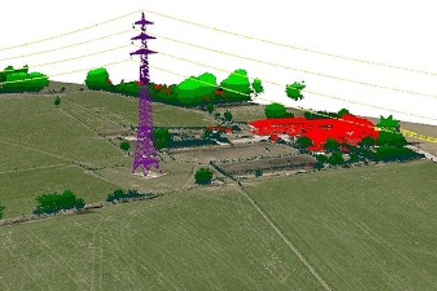
In 2011, Hansa Luftbild signed an agreement with the Ministère de l’Èquipment et des Transports (MET) of the Republic of Djibouti to perform an aerial survey for railway construction in Djibouti. The survey covered two planned railway alignments using laser scanning (LiDAR) technology. The result of the survey was used for a feasibility study and the preliminary design of the railway lines. The total length of the two alignments was around 265 km. The corridor width surveyed and mapped in 3D for each alignment was 500 m.
Based on the collected data, Hansa Luftbild generated a Digital Terrain Model (DTM) and the Digital Surface Model (DSM) of the surveyed area and produced Digital Orthophotos with 10 cm ground resolution. One of the largest components of the project, apart from airborne data acquisition, was the 3D mapping of objects and features. The topography was vectorized, ie mapped, using the laser data and the orthophotos. The legend for the features which were mapped was identical to that used in the Ethiopian Railways Corporation project for that Hansa Luftbild had aerially surveyed 5.060 km in 2010.
Please follow the link to read the full article:
Arab-German Yearbook 2014 - Construction and Consulting: Airborne LiDAR Survey for the Design of Two Railway Alignments in Djibouti.
(Editor: Ghorfa Arab-German Chamber of Commerce and Industry; www.ghorfa.de)